LiDAR vs Multispectral Sensors for Tree Counting
LiDAR and multispectral sensors represent two fundamentally different remote sensing technologies for tree analysis
Written by Amirhossein
Reviewed by Boshra
Recent advances in unmanned aerial vehicles (UAVs) and remote sensing technologies have significantly expanded the capabilities of tree detection and counting in forestry, orchards, and precision agriculture. Between these technologies, studies consistently report that LiDAR and multispectral imagery are the two dominant sensing modalities used for tree-level analysis, each providing fundamentally different information about vegetation structure and condition. According to the literature, multiple review and empirical studies emphasize that no single sensing technology is universally optimal for all tree counting scenarios, particularly in structurally complex or heterogeneous environments. Instead, sensor selection and data integration strategies strongly influence detection accuracy, scalability, and operational feasibility. In this blog post we are looking at basic concepts and also high-tech advances in tree counting problem.
Understanding the Core Technologies
LiDAR and multispectral sensors represent two fundamentally different remote sensing technologies for tree analysis. While LiDAR captures three-dimensional forest structure through point cloud data, enabling accurate tree detection in dense canopies, multispectral sensors provide spectral information that supports vegetation condition assessment and species differentiation. Their complementary data characteristics form the basis for hybrid tree counting workflows. Let's have a deeper look at these two technologies.
LiDAR Sensing
LiDAR (Light Detection and Ranging) is an active remote sensing technology that emits laser pulses and records the time delay of their returns to generate three-dimensional point clouds. Using this feature, UAV-mounted LiDAR systems are widely used in forestry due to their ability to capture detailed vertical forest structure, including canopy height, crown shape, and understory penetration.
Several studies demonstrate that UAV-LiDAR enables individual tree detection by identifying local maxima in canopy height models or by directly segmenting trees from raw point clouds using classical algorithms or deep learning approaches. These methods are particularly effective in dense forests where optical imagery suffers from occlusion and shadowing.
Multispectral Sensors
The second sensing method is Multispectral sensors that passively capture reflected solar radiation across a limited number of discrete spectral bands. They typically include visible and near-infrared wavelengths. These sensors are commonly deployed on UAVs and satellites for vegetation monitoring, species discrimination, and canopy condition assessment.
The application of multispectral sensing in tree analysis, is deriving vegetation indices and spectral features that correlate with tree vigor, species type, and canopy cover. Review studies highlight that multispectral data are particularly valuable in orchard and plantation environments where trees are spatially separated and canopy overlap is limited.
Point Clouds vs Raster Imagery
LiDAR and multispectral sensors fundamentally differ in the type of data they produce. LiDAR generates three-dimensional point clouds that explicitly encode spatial structure, while multispectral sensors produce two-dimensional raster images representing spectral reflectance.
Multiple studies note that point clouds are well suited for extracting structural attributes such as tree height and crown geometry, whereas raster imagery is more effective for capturing biochemical and spectral properties of vegetation. These differences underpin the complementary nature of LiDAR and multispectral data in tree counting workflows.
LiDAR vs Multispectral
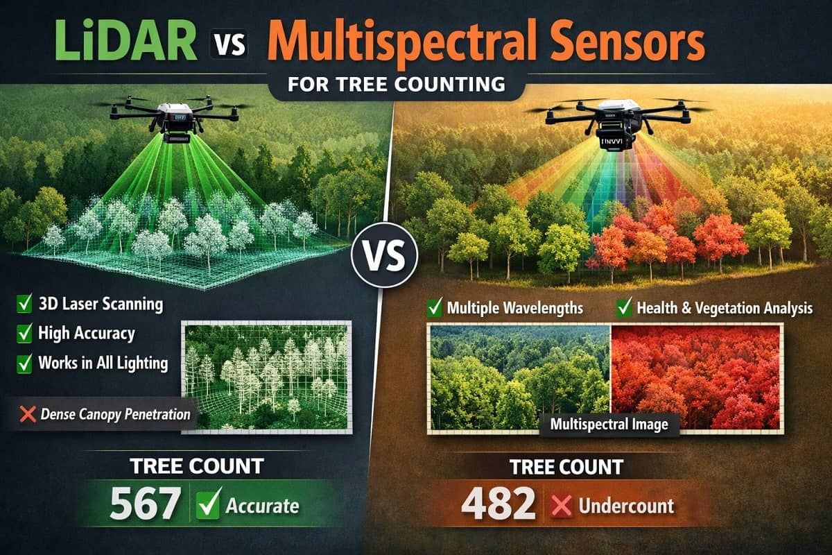
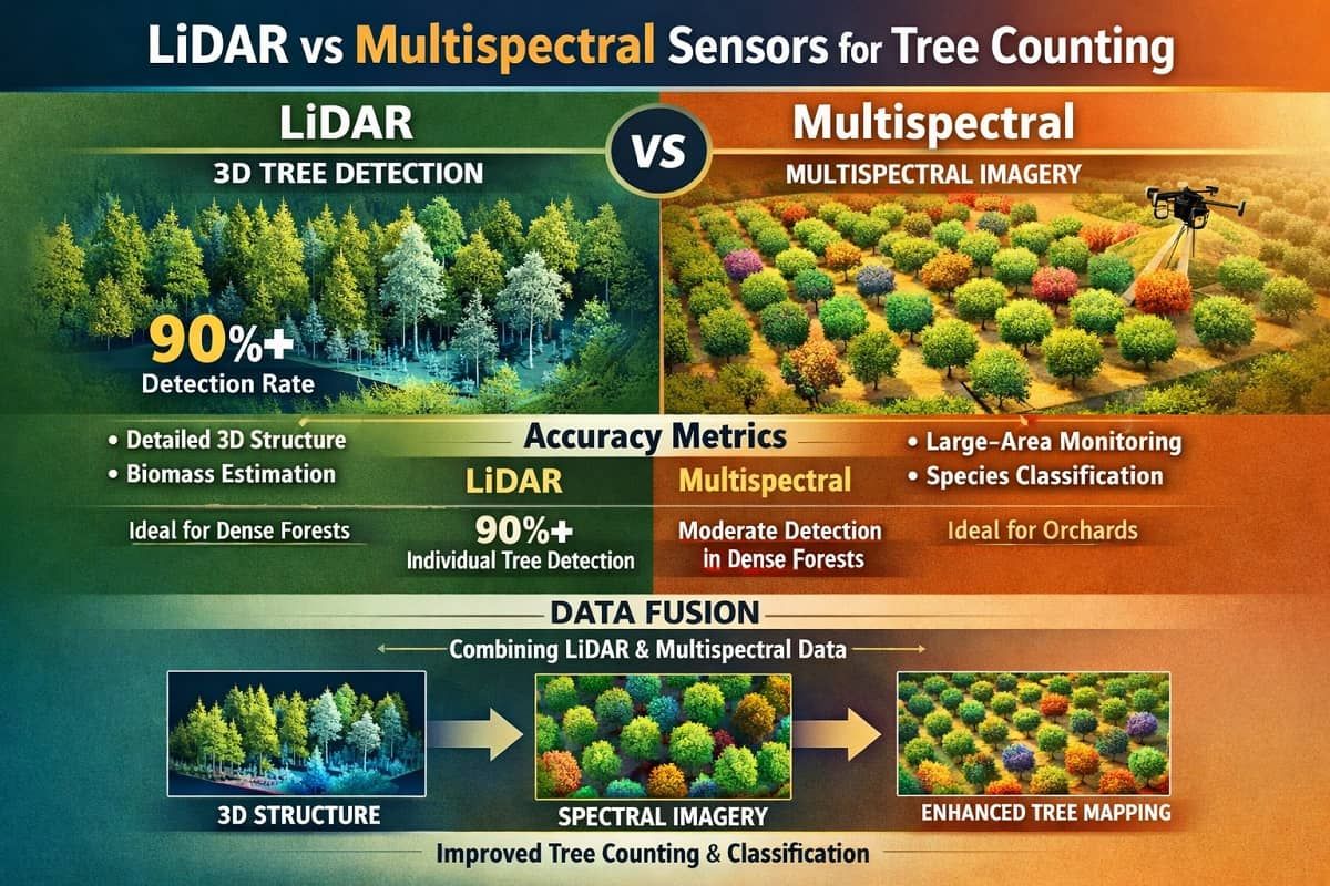
Studies indicate that LiDAR is preferable for applications requiring detailed three-dimensional structure, such as individual tree detection in dense forests and biomass estimation. On the other hand, multispectral imagery is more suitable for large-area monitoring, species classification, and orchard environments with simpler canopy geometry.
Accuracy Metrics
Empirical studies using UAV-LiDAR combined with deep learning show high individual tree detection rates, often exceeding 90% in both natural forests and managed stands. LiDAR-based approaches demonstrate strong robustness to canopy complexity and varying illumination conditions.
In contrast, multispectral-only approaches generally show lower detection accuracy in dense forests, particularly where crown overlap is severe. However, in orchards and plantations with regular tree spacing, multispectral imagery combined with instance segmentation models can achieve competitive performance.
Data Fusion
According to our studies, multiple surveys demonstrate that integrating LiDAR-derived structural features with multispectral spectral information consistently improves forest attribute estimation and classification accuracy. It has been shown that fusion approaches enable models to leverage both geometric and spectral cues, reducing ambiguity in tree delineation and species discrimination. Data fusion outperforms single-sensor approaches across various forest types, particularly in mixed and heterogeneous landscapes.
AI and Machine Vision for Counting Trees
AI and machine vision methods are used to convert LiDAR point clouds and multispectral imagery into tree-level detection and counting outputs. Recent studies emphasize that this process depends on two closely related factors: the choice of deep learning architecture used to process different data representations, and the segmentation strategy applied to delineate individual trees. Both factors directly influence detection accuracy and robustness across forest and orchard environments.
Deep Learning Architectures
Recent research applies deep learning models to both raster-based and point-based remote sensing data. For LiDAR-driven workflows, point-based neural networks and voxel-based 3D deep learning architectures are commonly used to directly process three-dimensional point clouds and extract structural information.
In multispectral and fused data scenarios, convolutional neural networks such as Mask R-CNN and transformer-based detection models are employed to identify individual tree crowns. These architectures treat tree crowns as distinct objects and learn spatial and spectral features simultaneously when multispectral and LiDAR-derived inputs are combined.
Instance Segmentation vs Semantic Segmentation
Semantic segmentation approaches classify pixels or points into predefined categories without explicitly separating individual trees. While effective for mapping forest cover, these methods are limited when precise tree counts are required.
Instance segmentation explicitly delineates individual tree crowns and is particularly effective in orchard and plantation environments with regular tree spacing. In dense forest canopies, overlapping crowns and vertical complexity remain key challenges for reliable instance-level segmentation.
Saiwa.ai's Machine Vision Platform: Scalable Tree Detection Solution
Automated Detection and Segmentation for Multispectral and LiDAR Datasets
At Saiwa we provide a machine vision platform Sairone designed to automatically perform many agricultural and green house services like tree detection and counting workflows across both multispectral imagery and LiDAR point cloud data. The platform supports automated tree crown detection and segmentation by leveraging deep learning models adapted to different remote sensing data representations. Rather than relying on a single sensing modality, one can work with multiple multisource remote sensing inputs, enabling users to apply LiDAR-based structural analysis, multispectral image-based detection, or hybrid workflows depending on data availability and project requirements. This flexibility directly addresses the variability observed across forestry, orchard, and plantation environments. For more information about these services please contact us at support@saiwa.ai or fill the request for demo form.
Cloud-Based Processing
To support scalability, Sairone platform implements cloud-based data processing pipelines that handle large volumes of UAV and satellite imagery as well as high-density LiDAR point clouds. This approach reduces the computational burden on local infrastructure and enables consistent processing across projects of different spatial scales. Cloud-based execution allows automated model inference, batch processing, and repeatable workflows, which are essential for operational tree counting applications where manual intervention and fragmented toolchains limit efficiency.
Integration with Drone and Satellite Workflows
In future, Saiwa will provide services to integrate seamlessly with existing drone and satellite data acquisition workflows. At the moment capturing and analysis steps have two separate workflows. This will give the users oppertunity to automatically transite from data collection to tree-level analytics without extensive preprocessing overhead. By aligning model deployment with standard remote sensing workflows, our solution bridges the gap between research-grade tree detection methods and practical, repeatable implementation in real-world forestry and agricultural operations.
Real-World Applications and Case Studies
Now let's have a look at some real-world applications. We are at a decade that UAV-based LiDAR and multispectral remote sensing have transitioned from experimental research tools to operational technologies in forestry and agricultural monitoring. Numerous studies report their effectiveness in delivering tree-level and stand-level information with higher spatial detail and temporal flexibility compared to traditional field-based surveys. As we will see in the sequel, these capabilities support applications ranging from forest inventory and biomass estimation to orchard and plantation management.
Forest Inventory and Biomass Estimation
LiDAR-derived structural attributes, such as canopy height, crown geometry, and vertical vegetation distribution, are widely used in forest inventory and biomass estimation. Also, UAV-LiDAR enables precise measurement of individual tree height and crown dimensions, which are key inputs for allometric biomass models and stand-level forest assessment.
According to our literature review, several studies demonstrate that LiDAR-based approaches outperform optical-only methods using RGB images in structurally complex forests, particularly where understory vegetation and multilayered canopies limit the effectiveness of image-based analysis. When multispectral data are integrated with LiDAR-derived structural features, forest characterization is further improved by incorporating spectral information related to vegetation condition and composition. This integration supports more robust estimation of forest attributes across heterogeneous forest types.
Orchard and Plantation Monitoring
Now let's discuss about application. In orchard and plantation environments, UAV-based multispectral imagery is widely applied for tree detection, canopy delineation, and vegetation condition assessment. Regular planting patterns, relatively uniform tree spacing, and reduced canopy overlap make these environments well suited for image-based analysis using deep learning models.
Instance segmentation approaches are commonly employed to delineate individual tree crowns, enabling accurate tree counting and canopy-level measurements. Studies report that multispectral imagery provides sufficient spatial and spectral detail for orchard monitoring tasks, particularly when combined with vegetation indices derived from visible and near-infrared bands.
Several studies also indicate that integrating multispectral imagery with LiDAR data improves robustness in scenarios involving uneven terrain, variable tree height, or heterogeneous canopy structure. In such cases, LiDAR-derived elevation and structural information complements spectral features, leading to more stable tree detection and delineation across diverse orchard and plantation conditions.
Conclusion
Current research demonstrates that both LiDAR and multispectral sensors play critical roles in tree detection and counting, each offering distinct advantages depending on canopy structure, spatial scale, and application context. LiDAR excels in capturing three-dimensional forest structure, supporting robust tree detection in complex stands; multispectral imagery provides valuable spectral information for vegetation monitoring, species-related analysis, and orchard-scale workflows.
Across multiple studies and reviews, hybrid sensing approaches that integrate LiDAR with spectral imagery are repeatedly reported to outperform single-sensor methods for a range of forest attribute and segmentation tasks.
However, practical deployment remains constrained by segmentation challenges in dense canopies (where performance can vary materially across stand types), operational issues such as co-registration accuracy and data quality management, and the compute demands of large-scale point-cloud and multi-modal deep learning pipelines.
Finally, bridging the gap between research-grade tree counting methods and real-world deployment requires platforms that can operationalize hybrid sensing and advanced machine vision at scale. Saiwa’s Sairone platform is designed to address this transition by integrating LiDAR and multispectral data processing within a unified, cloud-based machine vision workflow.
By supporting automated tree detection and segmentation across multiple remote sensing modalities, Sairone enables practitioners to move beyond isolated, study-specific pipelines toward repeatable and scalable operational solutions. Its cloud-based architecture directly addresses computational and scalability constraints reported in the literature, while its multi-sensor support aligns with the growing consensus on the strategic value of hybrid sensing for reliable tree counting.
Comments
No comments yet!
Table of Contents
No headings were found on this page.